Categories
Field Trip Folk-Lore Observation Poetry Psychogeography

Coastal (Being and) Time

” ‘Nature’ is not to be understood as that which is just present-at-hand …”

Martin Heidegger

DSCN1213-001

It is difficult to convey a sense of scale.

Perched on the edge of a collapsed harbour wall, the vestiges break from the blue expanse ahead like a stone-flippered sea serpent, emerging from the depths.

At this height, the field of vision is a wash of blues and greens, daubs of cloud. Dark emerald maps trace imaginary continents on the sea floor; an atlas of time and tide. Drowned oceans, swirls of bottle green bleeding through ultramarine. Hints of International Klein Blue. As a couple of herring gulls swoop close by and aim for the water, there is a fleeting urge to emulate Yves Klein’s leap

A whisper of wind, pulls the gaze back to the horizon and acts as a useful reminder that to leap from this vantage point would be unlikely to end well.  I press my back firmly against the narrow, elevated ledge and watch the clouds scudding east.

Whilst we could be gazing out across the Mediterranean, we are looking out over the Firth of Forth at Seafield, just west of Kirkcaldy. The collapsed harbour arm in front of us is an industrial folly dating from 1899. The harbour was never completed and looking towards the banks of serrated rock teeth, just to the west, it is perhaps not surprising why. It is difficult to envisage safe passage for any vessel across this bay.

DSCN1214

We are also aware that underneath these coastal waters, subterranean entrails of hollowed out ‘black diamonds’ reach far out below the Forth.  Behind us is a landscape of absence with no visible trace of the Seafield pit which once dominated this coastline. Seafield was the last of the Fife coalfield ‘superpits’ and was one of the largest undersea mines in Europe. It linked up underground, beneath the Forth estuary, with its sister pit, ‘The Frances’, situated to the North of Kirkcaldy.

Preparatory work on sinking a mine shaft at Seafield began in 1954 with production starting in 1965. The pit was one of Egon Riss’s (1901 – 1964) modernist designs for The National Coalboard Scottish Division, which also included: Bilston Glen, Killoch, and Rothes, with Seafield and Monktonhall being completed after his death. Riss was an Austrian of Jewish descent who had studied at The Bauhaus and was acquainted with Oskar Kokoschka and Paul Klee.

Seafield just managed to survive the fallout from the Miner’s Strike, but closed four years later in 1988 with all of the above-ground infrastructure erased from the landscape in 1989. A relatively short industrial life of 45 years from conception to dust. Walking the landscape today there is no trace of the pit having ever existed. A new housing development sits up on the hill where Riss’s modernist landmark towers once stood.  As we consider the marvellous views that these houses must command, we alight on a tomb-like structure on the side of the hill, complete with what could be a memorial stone.  All is blank.

DSCN1222-002

At the time of writing, (December 2015), the COP21 Paris climate deal has just been agreed, which at least outlines an intent and ambition to secure a low-carbon future for Planet Earth. We can’t help thinking that, like the oft cited butterfly of chaos theory that flaps it’s wings and causes a hurricane in another part of the globe, the burning of the first lump of carbon produced its own unforeseen effects over a longer time scale.

DSCN1205

“It was my first acquaintance (1859) with the geology of Fife, and furnished me with many fresh and striking manifestations of volcanic phenomena – a foretaste of the rich harvest which the county was afterwards to yield in the same field”.

Sir Archibald Geikie (1859)

Our sense of human time, industrial time and earth-time is given a further jolt as we start to walk along the rock strewn beach towards Kinghorn. This part of the Fife coastline offers some dramatic examples of rock formations and lava flows dating back to early Carboniferous times of between 360 – 320 million years ago. The Binn (hill) which overlooks nearby Burntisland is believed to be the source of these lava flows.

DSCN1243DSCN1237

.

Any rock is an index of deep time. Liquid lava movement arrested by abrupt cooling. Intense heat solidifying, fracturing, frozen in time.

Inevitably, our stroll along the beach throws up some interesting items:

We wonder if we have come across the staff of the Spear of Neptune:

DSCN1230

Unfortunately a search for the trident is unfruitful.

On any beach, these days, there is always at least one tyre:

DSCN1235

DSCN1310

A sea-smoothed anteater:

DSCN1242

and a rock pool submerged sea skull:

DSCN1246

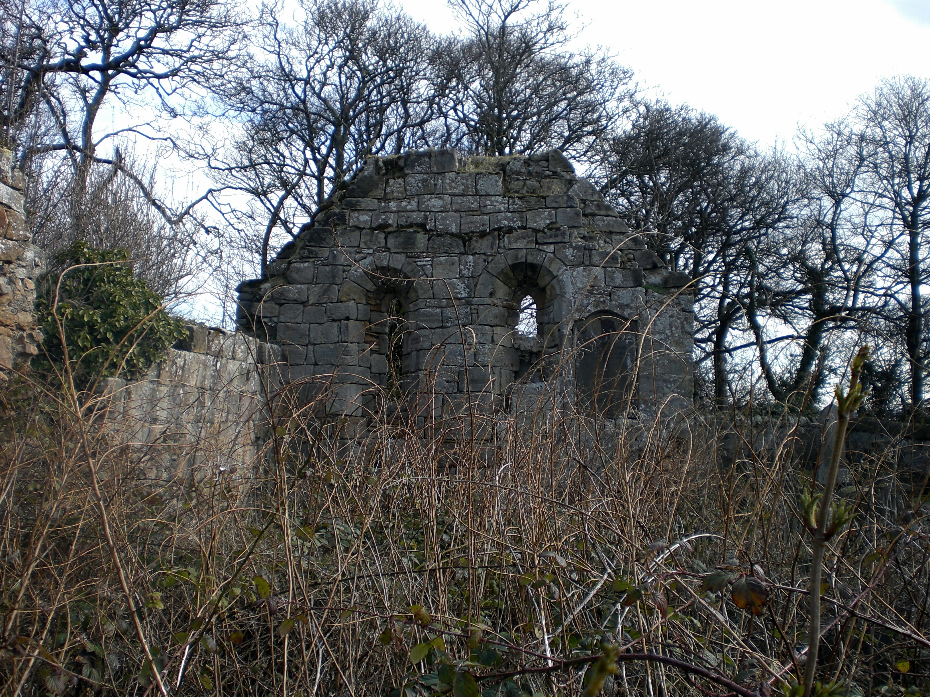
We leave the beach and pick up the footpath that leads to Kinghorn. Up ahead we can see the outline of Seafield Tower with the outer wall remaining largely intact.

DSCN1248

DSCN1252

For how long the tower will remain standing is another matter given the clearly visible fracture running down the middle like a poorly executed appendix scar. It feels as if a really strong wind could cleave the structure in two.

The tower is believed to date from the early 16th century and was the stronghold of the Moultrays of Seafield until 1631 when the estates were sold to the Archbishop of Glasgow. More intriguingly, a 1774 plan shows the enclosing courtyard walls and a circular tower at the NE angle described as the ‘Devil’s Tower’ although the derivation of this is unclear. The local coastline was known to be the haunt of smugglers in the eighteenth and early nineteenth centuries. Perhaps it would do no harm to circulate rumours about a devil’s tower to keep people well away.

Built of red sandstone, the tower has not weathered well and now resembles a crumbling, hollowed out old tooth:

DSCN1257

.

DSCN1259

DSCN1265

DSCN1262


DSCN1250
The Devil’s Tower?

On a day as radiant as this one, the tower doesn’t feel too devilish and the red sandstone softens the sun which is high overhead and beating down. This should favour one of the key reasons for our trip and we head further along the coast to see if we are in luck.

DSCN1273

DSCN1277

DSCN1278

DSCN1280

It is fairly common to see seals bobbing around the Fife coast, but we rarely see them congregate together.  Today they are revelling in the sunshine, lounging on a series of rocks not too far from the shore. Occasionally, one will slide into the water and bob around closer to shore, clearly curious but feeling well protected by the aforementioned waves of rock teeth to discourage anyone trying to get too close. This is also a very quiet part of the coast. The railway hugs the coastline between Kirkcaldy and Kinghorn which prevents any access to the path other than by foot from either end. Even on a day such as this, with glorious weather, we encounter less than a handful of people on the path. There are the usual dog walkers who populate the entrance and exit areas but otherwise it is a remarkably quiet stretch.

Not surprisingly, the area is also rich in bird life. Oystercatchers puddle around the shore, whilst common gulls and herring gulls criss-cross the air in constant movement. Further out cormorants dry their wings, as if juggling a pair of  half extended umbrellas.  Our identification skills are insufficient to precisely identify many other species but the area is known as a rich haven for guillemots, razorbills, kittiwakes and fulmars.

DSCN1226

Above our heads, a bunch of swifts engage in frantic aerobatics, explosions of kinetic energy and zig-zag movement. In stark contrast, a grey heron appears to slow the world to a standstill as it descends from the sky. The silent movement of its wings dissolving time in a held breath as it gracefully glides to a halt.

DSCN1286

DSCN1287

A more puzzling conundrum is the discovery of a still feathered wing caught up in some thick bramble thorns. Had the bird just inadvertently flown in to the thicket and become trapped or been attacked by a bird of prey? Or was it some totemic symbol carrying a message for the initiated or marking some form of threshold?

DSCN1285

As the path ascends to higher ground, it looks over some fairly steep cliffs and runs parallel with the railway line for a stretch with expansive views over the Forth and onwards towards Kinghorn itself.

DSCN1283

DSCN1284

DSCN1295

The presence of so many seals, earlier, conjures up visions of their close relatives in folklore whose stories pepper this coastline. As we look out to Inchkeith island we think of Kelpies and mermaids:

Kelpies

We eventually reach Kinghorn as the railway arches soar over our heads.

DSCN1299

Kinghorn will have its own post at some future time, but as we walk down to the harbour we are reminded that Pettycur Bay nestles under a prominent crag known as ‘Witches Hill’:

DSCN1301-002

≈≈≈

When the time comes to make the return walk back to Kirkcaldy, the sun has sunk low and we encounter no-one on the path. The landscape becomes more auditory than visual: the repetitive lip lip lip of a rock pool; the fizz of the receding tide. But it’s a low groaning drone that begins to fill the air. A deep and doleful lament rising to a eerie howl.

The seals are singing.

Is it a warning? a wake? Or do we hear the call of shape-shifting selkies, shedding their sealskins to assume human form …

We walk on quickly …

≈≈≈

Coda:

DSCN1353

Tired of dreaming

the sun slipped

from the sky


in the dying light

a fizzle of water

a settling of sand.


Now playing: Kevin Drumm – The Sea Wins

The walk was undertaken in late May 2015. Written up in December 2015.

Categories
Observation Psychogeography Some Questions of the Drift

Some Questions of the Drift

Weather vane, NSEW, blue sky, light
Kirk Wynd, Kirkcaldy

I ask you: 

– What is the weight of light?

– Clarice Lispector

≈ ≈ ≈

.

Merchant's House, Kirkcaldy
Merchant’s House, Kirkcaldy

.

.

 – What are the colours of time?

.

.

.

Merchant's House Kirkcaldy II
Merchant’s House Kirkcaldy II

.

.

 – What are the sounds of the stones?

.

.

..

.

.

.

 – When does the inside become the outside?

.

Rosyth Church - East Gable Inner - from West
Rosyth Church – East Gable Inner – from West

Gravestone, decay, erosion
St Cuthbert’s Churchyard, Edinburgh

.

.

.

 – What is the material of memory?

.

.

.

.

.

– What would the trees think?

.

Scot's Pine - Devilla Forest, Fife
Devilla Forest, Fife

.

Limekilns, Fife

.

.

– What is the geography of a butterfly?

.

.

.

CIMG1841
Lochore Meadows, Fife

.

.

– What is the shape of flight?

.

.

.

.

.

– When does the local become  – the universal?

.

Burntisland from The Binn

.

≈ ≈

– Where does the sky begin?

.

Digbeth Derive
Digbeth, Birmingham

– What is the taste of place?

.

Cafe now Open – Digbeth Birmingham


WP_000110
Custard Factory, Digbeth

.

.

– Where are the energy flows?

.

.

.

WP_000105
Abandoned factory, Digbeth

.

.

.

– What is the future of the past?

.

.

.

.

≈ ≈

Watching over Sauchiehall Street, Glasgow
Sauchiehall Street, Glasgow

.

.

.

– Who watches the watcher?

.

.

.

.

.

George Square, Glasgow

.

.

.

 – Who controls this space?

.

.

.

 – Who determines the boundary?

CIMG1210
Hadrian’s Wall
Berlin Wall
The Berlin Wall
Keep Out
Limekilns, Danger, Keep Out

≈ 

.

Sauchiehall Street, Glasgow
Sauchiehall Street Glasgow

.

.

–  Where is the coldness of the sun?

.

.

.

.

– What is the gravity of the moon?

.

at Mogwai play Zidane, Broomielaw, Glasgow
Rosyth Station, Car Park

.

.

.

.

.

.

.

– Where is the boundary of night?

.

Under Regent Bridge, Calton Road, Edinburgh (Callum Innes installation).

≈ ≈

.

.

Where is the future of  freedom?

.

Stirling Jail car park mural. Detail from Freedom Versions v.1

– What is the distance of love?

.

Berlin Wall, late 1980s. Looking towards the East

.

≈ ≈ ≈

Opening quote from Clarice Lispector’s The Hour of the Star.

The photos of the Berlin Wall are from an inter-railing trip in the late 1980s. It was a coincidence to rediscover them in an old shoebox on the day that it was announced Lou Reed had died.  I can still vividly recall a lurid, orange BASF cassette being pressed into my hand in the school playground. “Listen to this!”  It was a recording of Rock n Roll Animal. Things changed.

I can still remember a number of the cassettes that travelled in the rucksack on that inter-railing adventure. Berlin was certainly one of them.

Now playing: Lou Reed – Berlin. RIP LR.

Categories
Field Trip Psychogeography

Into the Void – A Field Trip

It is often the shortest journey, undertaken with least expectation, that offers up an excess of possibility beyond what we expect to see.

It’s always worth exploring the other side of the barbed wire fence.

Never keep to the path.

(Extracts from FPC Field Guide).

Time constrained by commitments later on in the day and yet compelled by the need to go for a walk, we settle on a local part of the Fife Coastal Path.  The very short stretch between Inverkeithing and Dalgety Bay is a narrow tarmacadam / cinder ribbon of a mile, or so, that meanders around the coastline.  Whilst  offering fine views of the Forth Rail Bridge and over to Edinburgh and Arthur’s Seat it is unlikely to trouble any tourist brochure. Indeed, the walking guide for the Fife Coastal Path devotes one short paragraph to it. There is a clear implication that this is a space that you can simply pass through.  It is also a functional path, popular with dog walkers, leisurely strollers and is even lined with street lighting. However, as the sign above indicates, the traveller is asked to keep within the marked path. We cannot help thinking of Little Red Riding Hood but can only read the sign as an invitation to stray …

There is a distinctive  topography to the land along this stretch of the path which edges around Inverkeithing Bay with sloping scrub and wooded elevations up to Preston Hill and Letham Hill behind. These factors and lack of road access, has prevented any urban coalescence between the nodal points of the old industrial harbour of Inverkeithing and the 1960s new town of Dalgety Bay.

Fife Coastal Path
Looking towards Dalgety Bay from Inverkeithing

However, there is also a distinct feeling of crossing a threshold, as you escape the gravity and material ephemera of the human settlement, and move into this zone from either end. A feeling of the wildness encroaching, long forgotten histories written into the land, whispered stories at the periphery of perception. A freeing up of the rules.

~~~

Lock-ups – Leaving Inverkeithing

Leaving from Inverkeithing, we walk past a row of lock-ups, that are not without some semblance of aesthetic beauty in their irregular order and contrasting colours. You wonder what is behind these out-of-the-way closed doors? Some have obviously not been accessed for some time given the overgrown vegetation in front. We also notice that as soon as you pass the last lock-up, the wild space is already there, encroaching green fingers, edging into the human space and into the photo frame. There is also a rather cryptic graffiti announcement:

Oot It
Entering / Leaving The Zone – Dalgety Bay

We are not sure whether to read this utterance as a comment on some existentialist predicament (“Out of it”) or a marker post to signify a transition point of moving out of the urban setting.  (Moving oot it). Later on, when we reach the Dalgety Bay end of the path we find more graffiti on the first inhabited house. There is a clear sense that both of these graffiti bookend an entry – or exit. We read these signs as an intimation that what lies between these threshold markers is a different place – a zone. Not urban, yet not rural. Not even ‘classic’ edgeland.  Instead, an indication that what lies within is an escape from the ostensible order of the settlements. Possibly a play area, a hidden place, an out of sight place, a gathering place, a wildness.

Follow the Desire Path

We are not far out of Inverkeithing when our advice to keep to the marked path is quickly discounted. We are drawn to the barbed wire topped, chain wire fence that we can see across a flat area of post industrial wasteland off to the left. It’s a pretty feeble attempt at preventing access as a whole section has been removed and most of the barbed wire has been snipped off.

We follow the well trodden desire path through the fence to find ourselves in the heart of the abandoned Prestonhill Quarry, now filled up with water. There is a compelling, uncanny beauty to this place. A void gouged and hewn out of the Earth, with the remaining dolerite walls reflecting weak sunlight like a cubist canvas.  The acoustic ambience has also noticeably changed. We are in a huge reverberating chamber so that the slightest noise pings around the walls. A distant ice cream van sounds as if it should be coming from somewhere within the quarry, possibly submerged underneath the water. At the same time swallows dart and zig-zag above our heads, whilst magpies hop and skip around the top rocks, observing us with curiosity.  A couple of buzzards circle in the distance .  There is no one else around.

Prestonhill Quarry – Cubist Walls I
Cubist Walls II

What is noticeable is that even in these most barren of conditions, non-human nature is restaking a claim with outcrops of growing vegetation, clinging to the quarry walls, thriving in the most hostile of conditions and the thinnest scrapings of soil.

Cubist Walls III

We soon find the ubiquitous discarded fridge. Lying face down, its broken body surrounded by other accumulated fly tipped debris. The human stain of the dumping ground. It is always a puzzle to consider the time and energy it must take to fly tip a fridge in an ‘out of the way’ area, such as this, compared with taking it to the recycling point. Perhaps it’s for the sheer visceral thrill of throwing a fridge into a quarry. We assume that it has been pushed over the top and has been there for some time.

~~~

There is perhaps another attraction of the quarry. It is an unseen place with very deep water.  Every surface has another side. What else lurks underneath the skin of calm blue water?  What is submerged down there in the green depths with the little fishes?

~~~~~

g

o

i

n

g

~~~~~

b

e

l

o

w

~~~~~

t

h

e

~~~~~

s

u

r

f

a

c

e

~~~~~~~~~~~~~~~

Prestonhill - Submerged I
(c) Zibi
Submerged II
(c) Zibi
Submerged III
(c) Zibi
Fish in Prestonhill Quarry (c) Zibi

All underwater photographs of the quarry are by ‘Zibi’ and can be accessed here along with many others. Whilst we have attempted to seek permission from Zibi to use these images, we have not received any reply to our request.  Clearly if our request is subsequently refused we will remove the photographs from the blog but in the meantime were are grateful to Zibi for their inclusion.

It would appear that the quarry is also a favored disposal spot for stolen cars, making for an ideal symbiotic relationship with the diving community who find the quarry an attractive destination for underwater exploration. There is plenty to see and investigate below the surface. We are also told later that local fishermen stock the quarry with fish which they then try to catch again, fostering a fledgling underwater eco-system.  There are rumours that someone may have introduced a pike.

~~~

The quarry is also clearly a gathering place. A hidden place of escape and unregulated recreation.  We walk around the void, recording some of the many tags that have been written on to the rocks.

FTW – Mr NIce
JC Waz Ere
Billz, Coco, Jamie, SKAK
Anarchy

Staring up at the quarry wall and contemplating the material passage of time ossified in these rocks. The play of light on the angular shapes conjures up dynamic planes of movement and appear to imbue the rocks with an almost animistic quality. We can eventually see a cubist rock giant, emerging from time with right arm raised:

Emerging Cubist Rock Giant

~~~

Back on the path, we head off to the right hand side this time.

Stretching out over the water is a fretwork pier of rusting metal which we find out later was the old industrial conveyor system used to load the quarried stone on to tethered ships.

We stand for a while to listen out for the lost sounds of this place. The kling klang ghosts of the industrial machinery, the heft of monolithic slabs of dolerite rattling down towards the waiting ships.

almost silent now

now almost silent

only the ack-ack-ack

of a solitary gull

riding the wind currents

overhead.

A large steel plate has been placed across the structure presumably in an attempt to prevent people from climbing out along the pier. It’s unlikely to be a deterrent but it no doubt satisfies some health and safety regime. The plate has rusted and weathered into something resembling a Richard Serra sculpture:

Richard Serra ?

Once again, we can see how the wildness is staking its claim with tendrils of green growing up, through and out of the lattice structure. “Shugg and Leanne” evidence the human urge to make a mark. The basic proof of existence. A name recorded. A demonstration of love?

Running parallel to the fretwork structure is another abandoned jetty. The pulleys remain suspended from the cross beam conjuring up something of the gibbet or perhaps some form of cosmic launch mechanism to project the traveller up and into the pillows of cloud:

all of this

abandoned history

lost stories, forgotten stories 

sounds of absence

whispering in the wind.

We decide to explore a bit further underneath the conveyor structure sensing that this may yield possibilities.  We are not disappointed when we alight on this gathering site:

What is noticeable is that there is no rubbish strewn here. It’s as if this is a place of respect. Strangely enough, the atmosphere evokes a similar feel to another outcrop of rocks that can be found on The Binn (Hill) along the coast at Burntisland:

Rock outcrop, The Binn, Burntisland

Humans have also made their marks on The Binn stones, albeit some 4,000 years earlier

Cup and Ring, The Binn, Burntisland

~~~

We pick up a bit of walking pace to take advantage of the seascape.

a sounded wave, persistent and seductive –

plays the shoreline.

flux and flow of sea brine –

a spilling over

of elemental energy.

Once again the unusual topography is such that we can hear a mash-up of field and hedgerow bird song against foreshore waders and gull talk.  A chorus of crows, darting finches and tits; a wren bobs along the wall before taking refuge in the trees. What looks like a falling red leaf is actually a robin. On the foreshore, oystercatchers, and curlews wade and waddle whilst fulmars, cormorants and herring gulls dive and swoop. Symphonies of birdsong and gull chatter.

It doesn’t take long to reach Dalgety Bay, but just before the threshold graffiti we come across this:

Abandoned House Dalgety Bay

Roofless and abandoned, it looks as if all of the surrounding land has been sucked away from the foundations leaving it sitting like an old tooth stump.

Doorway to Nowhere

We try to piece together a narrative here but fail. Why has it been abandoned? Why left to ruin? It was clearly a property that had wealth behind it at some point, sitting in its walled garden. Enquiries are made of a few passing locals but yield nothing.  “It’s always been like that” says a man who looks to be in his forties. “Ever since I was a wee kid”. He doesn’t know the story though.

~~~

We are on the reverse trip back to Inverkeithing when we spot a small opening in the stone wall with a signpost:

How could we resist? Off up the rickety path which didn’t appear overly well trodden.

We find a beetle on its back on one of the steps clearly distressed. A multitude of legs. flailing wildly, unable to right itself. We soon tip it on to its feet and the little jet black shell scuffles off into the grass.

The path ascends fairly steeply and it’s not long before we find ourselves on a high ridge which slopes away towards Letham Wood. That will have to wait for another day. Our immediate area of interest lies off to the left. Another barbed wire fence and it’s as easy to circumvent as the last one. This is what we had been leading up to. We could already feel what we were about to witness but were unprepared for the sheer scale of it.  Compared to the ground level, water-filled heart of the quarry, we could now gain a perspective of the entire void and walk right up to peer over the edge.

The Void
The Void II
The Void III

Peering over the side, into the void, it’s as if a vacuum is trying to suck your insides out. I’m reminded of Aragon in Paris Peasant and the ‘suicide bridge’ in Buttes Chaumont park – coincidentally built in a reclaimed stone quarry.  Before metal grilles were erected along the side of the bridge, it would supposedly claim victims from passers-by who had had no intention whatsoever of killing themselves but found themselves suddenly tempted by the invocation of the abyss.

Our photographic skills are unable to adequately capture the scale of this almost mournful absence, hewn from the Earth. It’s a place to simply sit and stare for a while.

.

.

.

.

.

.

It’s often easy to forget to raise our heads to the horizon. Having escaped the seduction of the void, we now realise how high up on the ridge we are. It changes our sense of the whole topography of the area. We can see how connected we are to the East side of Inverkeithing and marvel at the long view over to Dunfermline. We can see Spinner in the distance with the distorted perspective making it appear as if it is growing out of a housing estate.

Spinner

We later discover that there is also an abandoned WW2 radio station complete with intact pill boxes not too far away but don’t see them today.  Another time.

We descend back down the hill to the coastal path and reflect on our experience. What we had anticipated as a short, local coastal walk had been transformed into something else. A journey through a zonal space teeming with encounters and traces of the human, non-human and even the animistic.  A co-existence of dumping ground, liminal playground, gathering place and nature sanctuary.  The transient narrative of human activity inscribed in the abandoned house and the mute quarries and jetties a reminder of how financial capital abandons one exhausted void to migrate to the next site of profitable extraction.

Above all of this, the continually changing drama in the sky:

Sometimes it’s in the sky when you look – Buzzard dots
Looking to Arthur’s Seat and Edinburgh

Eye in the Sky

And as we return to Inverkeithing we can smell the sweet wood lying in the still functioning timber yard and take one last photo. It’s only later, that we notice that in this photograph, and almost all of the others, there is some intimation of wild nature straying into the frame.

An alert wildness, observing, perhaps patiently waiting for its moment to come.

.

.

.

.

.

~~~~~~~~~~~~~~~~~~~~~~~~~~~~~~~~~~~~~~~~~~~~~~~~~~~~~~~~~~~~~~

This has been a little slice of:

From The

Now Playing: James Plotkin : Mark Spybey – A Peripheral Blur