Hi-rise tower blocks at Seaton Place, Falkirk, built 1965 – 1969.
Home of the estate factor of Callendar House, a listed building with stable court, stable blocks, dovecot and implement shed. Now derelict and on the buildings at risk register.
Just to the north of the hi-rise towers lies the route of the Antonine Wall which stretched across the Central Belt of Scotland between the Firth of Forth and the Firth of Clyde. Construction of the wall began in 142 AD, taking around twelve years to complete.
Now playing: Harold Budd – The Oak of the Golden Dreams.
ice blue hue of early morning / / settled setting of frozen music / / arrowhead stave aimed at the stars / / rhythms inked on starless starlight [ crack crack – cacophony crescendo ] winged chorus sounded in flight / /
settle / / settled / / disperse / / dispersed
still / / stilled / / stillness
At Capernaum Pier, Limekilns. Early morning 21st January 2017.
Now playing: David Cross & Robert Fripp – Starless Starlight
the habit of dreaming and the ability to dream are primordial
Fernando Pessoa
.
adrift
casting a line
to pull down
the stars
.
.
at the threshold
of hearing, sounds
of the city, stored
in the stones
.
.
thought bubble
of the white dove
fractured figments
of translation – PA?
.
.
dazzle me
with dreams
of a kinder
kind of blue
.
.
even electrons
get lost
in the forest
(scratch) —–>
this way
≈≈≈
From a walk through the New Town of Edinburgh on 14th January 2017.
(Edinburgh’s) buildings are dominated by locally quarried sandstone so that the stone-built heritage literally grows out of the bedrock foundations of the city. (McMillan and Hyslop, The City of Edinburgh: Landscape and Stone, 2008).
Now playing: Morton Feldman – Triadic Memories (Steffen Schleiermacher).
To begin the journey, we congregate almost four hundred years after Jonson. In front of the Palace walls, a set of variations in muted ochre, the orange pantile roof catches weak strands of sunlight on this September morning …
It was a delight to be part of this wonderful project where we took Ben Jonson out for a walk in September.
Rebecca Crowther has documented the activities of all who took part in a new website which records our nine mile social walk from Culross to Dunfermline. Here you’ll find some background to the project, photographs, a short video, sound recordings of our interactive stops along the way and our own contribution from Murdo Eason.
Some extracts below:
still
s
i
t
t
i
n
g
In a quiet place
I watch the sky
fall to earth.
.
A few leaves
cast adrift, circle
as clouds and trees
slip silently below
the skin of water
≈≈≈
The sock & coulter symbol of the plough. A farmer’s life, turning soil, slowly returning to the land
The concept includes the fact that many foreigners have settled in Scotland and contributed to its identity. Indeed, the notions of geology as destiny, the Rock People, and the Atlantic People that plied the shores from Galicia to Norway (from roughly 5,000-1,500 BC) are part of the larger Scottish World …
Charles Jencks
Anyone who has driven up the M90 motorway in the last twenty years could hardly have failed to notice the St Ninians open-cast coal mine near Kelty.
A landscape transformed and consumed through raw material extraction, technology and human labour. The coloured flecks of jabbing industrial machinery appearing to shrink to insect scale as the vast grey void opened up. An unfolding Burtynsky portrait of post-industrial scarring:
St Ninians from the air (c) Ken Whitcombe
In 2003, the international landscape artist and cultural theorist Charles Jencks was commissioned by the mine owners, Scottish Resources Group, to develop a landform proposal to regenerate the area. Jencks is perhaps best known as an architectural theorist of postmodernism and in Scotland, for landscape design projects such as his own Garden of Cosmic Speculation, the recently completed Crawick Multiverse and smaller scale works at Jupiter Artland (Cells of Life) and The Scottish National Gallery of Modern Art (Landform Ueda).
Jencks coined the project The Scottish World which was based on ideas of the Scottish diaspora and immigration. There was no doubt as to the physical scale of its ambition with four colossal earth mounds representing four continents where Scots had travelled and settled.
Whilst work commenced on the restoration project, and was originally due to complete in 2012, the scheme collapsed in 2013 when Scottish Resources Group went into administration. The site was subsequently taken over by Hargreaves Resources and an agreement was made with Fife Council that would see a degree of the restoration project completed, in exchange for a licence to extract the remaining coal still to be mined. However, it soon became clear that the project would not be completed according to Jencks’ original design although elements already completed would be kept and maintained. Despite occasional mutterings in the local press about potential futures for the site, it appears to exist today in a state of limbo ‘officially’ out of bounds to the general public.
We thought we would go and take a look.
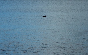
It seemed barely credible that this was the first weekend in October as we headed in a vague direction towards the contours of the limbo landscape. First, a short detour to Loch Fitty, looking serene, underneath brilliant blue skies punctuated by billowing clouds scudding overhead. A solitary duck on the water placed like a calligraphy mark on a sheet of blue marbled paper.
Looking out over the loch today, it is difficult to comprehend that in 2013, there was a consented planning proposal on the table to drain the water and excavate 7.4m tonnes of coal underneath. (How do you actually drain a loch?) The scheme was only curtailed with the afore-mentioned collapse of Scottish Resources Group. However, the presence of coal workings in the landscape remains evident with a line of black, sooty debris drawn along the shoreline.
From the loch, we couldn’t find any obvious path towards the Jencks landscape but as the ‘European Continent’ mound dominates the area it is easy to set a course towards what looks like a primitive temple complex at the apex of this earth shifted landform.
The weather clearly helped, but the biggest surprise is how the black scarred earth is now re-seeded with lush golden grasses and whilst waterlogged in parts is perfectly suited to walking. At the bottom of Jencks’ colossal mound, it is identifiably one of his structures, but a rustic, wild version on an explosive scale. All ragged gorse and tufted grasses compared to the carefully turfed manicured versions displayed as artworks. The walk to the top of the earthwork is like walking around the structure of a snail’s shell. An ascent around the unfolding whorls giving spectacular views as we circle higher. Looking to the north, a large body of hidden water provides a sanctuary for a sizeable colony of birds – too far away to identify what they are:
Further around the structure, we look upon another of the completed mounds redolent of Silbury Hill. Will this structure also retain its mysteries when future generations ponder who built it and why?
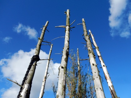
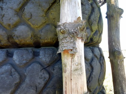
At the top of the European Continent mound, three tyre and tree structures point to the heavens. Postmodern totems evoking some sense of being placed in a ceremonial landscape. From the highest point, sight lines lock into the elevated energies of the recumbent figure of Benarty Hill, Falkland Hill and what Julian Cope calls the mother mountain of Largo Law.
The earth spread out beneath us is a material energy landscape still in flux as it has been for thousands of years. The extracted open-cast void surrounding us directly below. To the east and west a landscape shaped by the deep mining of the Fife coalfield and the towns and villages that grew on the back of it: Kingseat, Ballingry, Kelty, Cowdenbeath, Lumphinnans, Lochgelly, Lochore, Cardenden, Auchterderran. The pit winding gear long since removed from all these places. (although we can still see the winding gear structure of the Mary Colliery at Lochore Meadows which has been left as a memorial to Fife deep mining).
There is also an absence. A village now completely erased from the land on which we are pretty much standing:
Reproduced with the permission of the National Library of Scotland
Lassodie, in the Parish of Beath, was an agricultural community up until the mid-nineteenth century. In 1859, the Lassodie Coal Company was established and a number of pits were sunk which resulted in new housing being built locally for the miners.
By the early 1900’s, Lassodie housed around 1,400 people and included a village school, a number of shops, including two branches of the Co-Op, a Free Church of Scotland and a corrugated iron village hall. However, like many of the Fife towns and villages, the fortunes of the community were inextricably linked to coal. Two pits were closed after the 1921 coal strike which set in motion the gradual drift of families away from the village. By 1931, all the pits had been closed as they had become uneconomical to keep free from flooding. The remaining families were served fourteen days notice to vacate their houses which were owned by the coal company. The church struggled on for a number of years as a Christian retreat and was used at the beginning of the Second World War as a hostel for refugees from Nazi occupied Europe. The buildings of the village were eventually demolished and almost all material traces of it having ever existed disappeared when open-cast mining transformed the land. A memorial to Lassodie villagers killed in the First and Second World Wars now sits in isolation at the side of the B912 road from Kingseat to Kelty. Detached from its physical referent it now also acts as a memorial to the ghost village itself.
Image taken & added 22.10.16Image taken & added 22.10.16
To the South East, the Mossmorran natural gas fractionation plant is clearly visible, belching plumes of steam into the sky. A folded mass of metal glinting in the sun. In the far distance, the colossal turbine structures of Little Raith wind farm spin silent songs of wind alchemy.
An avenue of coal machinery parts has been placed on top of the structure. Transformed from utilitarian metal and concrete into slowly changing collection of weathered patinas across the colour spectrum:
.
On a landscape of rust
canyons and deserts
of the colourfield
.
.
Locked rotational
orbits gather
slow accretions
of elemental colours
.
.
On top of
a human-formed hill
.
Eyeing the curve
of concrete shadow
.
Edges and angles
cutting through the blue
.
.
enfolding
shadows
f / o / l / d
spaces
of retreat
.
A causeway of hewn rock offers a puzzle to ponder: Stencilled into two rocks: Danzig and Gdańsk. The same physical place that has oscillated between variants of these two names, Prusso-German rule, Polish rule and as a semi-autonomous city-state between 1920 and 1939.
The stones are likely symbols of the strong trade links that Scotland enjoyed with the Baltic region from the late fourteenth century onwards. Many Scots emigrated to the Baltic region and established themselves as merchants and traders. Robert Gordon was one merchant who made his fortunes through the Aberdeen-Danzig trade route. He subsequently funded the foundation of a hospital in his hometown which four hundred years later still stands, now known as Robert Gordon University. By the 17th century Gdańsk was home to an estimated 30,000 Scots and today two suburbs of the city exist called Nowe Szkoty and Stary Szkoty. (New Scotland and Old Scotland).
On another split stone, a French proverb Fier comme un Écossais(Proud like a Scot) is a reference to the Auld Alliance between Scotland and France, established in 1295.
Proud like a Scot
One of the most surprising aspects of the whole area was the constant presence of dragonflies – if indeed that is what they are? – flitting past, resting, or sunning themselves. Magical, flying shards of stained glass, as if materialising out of light and air. I have never seen so many in one area, so ecological conditions must be very favourable for them. Perhaps tangible evidence of a healing landscape.
On the way back down, we reflect on the connections this walk has tapped into. The sense of landscape always being in flux; old energies transitioning to new energies; the wounds of open-cast mining in a process of environmental healing. Of how an outward looking internationalism has been part of the Scottish (and British) psyche for hundreds of years. How we have welcomed refugees in times of crisis. A reminder of how vital this is as resistance to the current raft of Brexit ideologues, attempting to build walls, retreat to nostalgic notions of a country that never existed and shrink imaginations.
And as for Jencks’ stillborn project, we say open it up as it is. It has developed into a fascinating space for walking; nature appears to be transforming the ecology and it is clear that people have started to use it unofficially. On the way back we pick up a path that is easily navigable as an entry point to the site and encounter a few dog walkers and people out for a stroll around the lower levels. A conversation with one of the miners who used to work here illustrates his pleasure in how the land is usable again. He also regales us with a few tales of tax scams and financial deals that he believes went on regarding the management of the site and the failure to create a sufficiently large sinking fund to enable full restoration to take place.
The land is there. Go walk it!
With very special thanks to Kathryn B, who pointed us in the direction and found gold in these lands!
Now playing: Laurie Spiegel – The Expanding Universe.
The opening address by Phil Smith (aka Crab Man, aka Mythogeography), is a fascinating and thought-provoking missive on the state of psychogeography and the walking arts today. You can read, download and share it here:
Also check out Phil’s Mythogeography website – ‘an ambulatory goldmine’ and his books published by Triarchy Press.
≈≈≈
One of the points Phil makes is the need to rethink the drift on a smaller scale. In the gaps, in the smallest fractures, in small disruptions to personal routines; the late running of a train that allows you a few minutes to explore the hinterland around a station.
A recent personal example was the unexpected distress visit to a garage when a section of exhaust pipe fell off the car. Whilst the new part was being sourced and fitted, a short walk around the immediate environs:
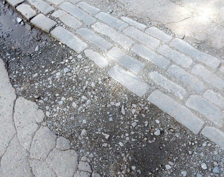
Crack-
ed slab scree
c o b b l e s
c o b b l e d
in p O O l
-ing light
≈≈≈
Now playing: The Soft Machine – s/t (with a nod to Boyle Family).
Next Sunday, September 25th, we are participating in a social walk which takes its inspiration from tracing Ben Jonson’s journey from Culross Palace to Dunfermline Abbey nearly 400 years ago. The walk is part of a wider project initiated by the University of Edinburgh led by James Loxley and Anna Groundwater. Below you will find full details of the event and you would all be very welcome to join the walk in full or in part. If you require any further information please drop us a comment or contact Miranda Swift directly (miranda.swift (at) @ed.ac.uk)
Hope to see and meet some of you there!
From Miranda Swift:
SUNDAY, SEPTEMBER 25TH
JOIN US IN TRACING BEN JONSON’S WALK FROM CULROSS PALACE TO DUNFERMLINE ABBEY
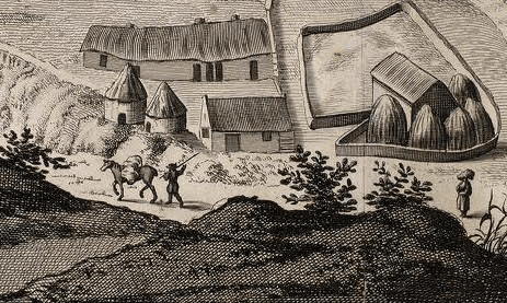
Detail from John Slezer’s Prospect of Dunfermline, 1693
Nearly 400 years ago, Ben Jonson travelled on foot from London to Edinburgh, and from there to Fife. He took his time, stopping at inns and private houses, meeting new people and socialising, listening to stories and telling his own. It’s this kind of travel that we’ve taken as the inspiration for a social walk from Culross Palace to Dunfermline, following the route that not only travellers like Jonson, but local folk as well, have long been taking.
Along with some fantastic collaborators from Forth Pilgrim the Fife Psychogeographical Collective and Fire Station Creative , we’ll be joined by a diverse crew of walkers, including storytellers, artists, musicians, and historians. To help us gather the sights and sounds of the landscape, as well as our responses to it, we’ve invited film and photography students from Fife College to come along, and we’d also like to encourage everyone to get involved with as much or as little participation as you like. Bring a sketchbook, a poem, a camera, or just your walking boots!
The total distance is 9 miles, however you’re welcome to join us at the start and leave at any point along the route, join us at our mid-way stop at Cairneyhill and carry on, or meet us at at the Fire Station Creative in Dunfermline at the end, and join in the party. We’ll be treated to some excellent live music from local Fife musician Andy Shanks, as we swap stories and rest our feet.
For a little bit of background on Ben Jonson’s walk, and the University of Edinburgh project, led by James Loxley and Anna Groundwater, which this walk is a part of, check out Ben Jonson’s Walk. James has also written up a blog post on our upcoming Fife Social walk, delving into Jonson’s attitude towards travel and discovery, which you can read here:
This walk is open to all, so please forward this information on to anyone who you think might be interested, and we look forward to meeting you.
ITINERARY
10:15 – Meet outside the front of Culross Palace in the square, look for the bust of Admiral Cochrane
10:30 – James reads from Jonson’s account of the Palace
10:40 – Set off
13:00 – Refreshment break at The Maltings Hotel, Cairneyhill
16:00 – Finish at The Fire Station Creative, Dunfermline
16:00 – 19:00 – Social gathering with music, poetry, and good company
INTERACTIVE WAY-STATIONS
You may have noticed the yellow marks on our map. These are stopping points where some of our participants will be leading interactive sessions, which will include:
Local stories, myths, legends
Focusing-senses exercise
Local history (George Bruce’s moat pit, Newmills Bridge, etc.)
Poetry readings (Thomas A. Clark’s ‘In Praise of Walking’)
DETAILS
Date: Sunday, September 25th
Time: 10:30 am – 4:00 pm
Start: Culross Palace
Finish: Fire Station Creative in Dunfermline. It is located next door to the new Tesco on Carnegie Drive, KY12 7AN.
Distance: 9 miles. Please refer to the maps attached for details of the route taken, marked in red.
Joining/Leaving: A convenient meeting place should you only want to walk part of the route is The Maltings Hotel, Cairneyhill. We aim to reach it by 1pm for a short refreshment break.
Transportation: Please refer to the bus schedule on Map 1 attached here. Bus 8 leaves stance 11 at Dunfermline Bus Station at 9:35 on Sunday, arriving Culross Palace at 10:03. Further bus information, including bus times from Culross and Cairneyhill to Dunfermline, are also attached to Map 1. Alternatively, visit the Stagecoach website, or ring 01592 645680 for up to date info.
Accessibility: The route will follow footpaths, though be aware that surfaces may be uneven in places, and you are responsible for your own safety when using them. We will be walking along the coast for the first half, and then walking up a couple of hills. It is not a difficult hike, but be prepared for a long walk, and remember to bring enough water with you.
Meal Break: Please bring a packed lunch with you. Due to the number of people and the time restrictions of the walk, we won’t have time to be served lunch in the hotel. There is a shop in Cairneyhill where you can buy a sandwich if you find you forgot yours, or need two!
If you have any further queries please don’t hesitate to get in touch with me, the project administrator, via email or by phone. I’m always happy to chat about the project, and will hopefully be able to answer your questions. Also, if you could let me know if you will be attending, please let me know. Thanks in advance, and I hope to see you on the walk!
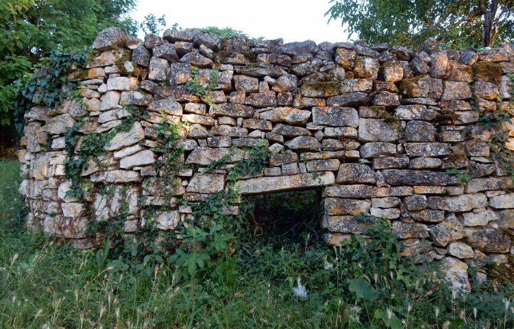
No neatly packaged hay bales in the uncanny rural. Creatures of twilight, sit hunched in the corner of smallholdings, backs turned. In fading light, walking past these halo-skewered field dwellers: was that a lengthening shadow? a sigh? a suggestion of movement?
IV
They would appear in the adjoining field at around 7.00pm each evening. A symphony of bells heralding their arrival. We never did see where they came from. They would feast in the field for around half an hour, a clanking cacophony of movement. Occasionally, one would come over to eye us up, usually the smallest with the highest pitched bell. Curious young eyes stared us out. Yet, these eyes tapped into something much older. Some fundamental rhythm of the land. Jaws rotating in perpetual motion and then, as they do, leaping into the air as if the earth had administered an electric shock to their hooves. A display of exuberance and delight in contrast to the slow, deliberate movements of the herd elders. They kept their heads down, chewing, chewing, chewing. After a cycle of time, which we were not party to, the deepest, most sonorous bell started to sound out a rhythm. The largest goat of the herd was calling time and starting to amble away. Gradually, the other goats began to follow, bells around their necks congealing into a moving mass of sound. A few short explosive trills as the stragglers ran to catch them up. We watched as the herd turned a corner and listened as the bells faded into the distance.
V
A visit to the small hilltop town of Motovun and very surprised to meet this straw giant and his dancing acolytes. Staring us out with his silent gaze, he must have been over twenty feet tall, At his feet, some folk ritual or dance taking place, arms thrown open to embrace the sun. Something of the Wicker Man about it all.
As far as I could find out, his name is Veli Jože, a giant who lived (lives?) in a local truffle-rich forest. Local stories suggest that he has been known to enter the town and physically shake the church tower to sound the bell.
To reach Motovun, it is a steep walk up the hillside to reach the town perched on top. Whilst not religious, was touched by the care and beauty displayed in the construction of this minimal roadside shrine.
Motovun sits is on a hill in the Mirna valley and evidence of human settlement dates back to prehistoric times when it would have been surrounded by water. The river Mirna is Istria’s longest river and legend has it that Jason and the Argonauts fled down the estuary after having captured the Golden Fleece.
.
VI
Another hill-top town, this time with a twist. Dvigrad is a relatively well-preserved mediaeval ghost town in the Draga valley. The population was initially decimated by the Black Death in the 16th century and finally abandoned completely in the early 1700s. As the town was unoccupied, it was spared from the destructive ravages of war which were a constant feature on the Istrian peninsula. Today, the town gates still exist, and it is possible to walk around the town walls. The defence tower still rises to cut the blue sky and interior room structures of the 200 odds houses are clearly visible.
.
VII
Aura of the town walls: return of the gaze:
To perceive the aura of an object, we look at, means to invest it with the ability to look at us in return … when this expectation is met … there is an experience of the aura to the fullest extent.
Walter Benjamin
.
VIII
Amongst the networks of rural paths and tracks.
Always the walls:
Stacked
Held
Holding
.
IX
Entropic Futures.
An alien structure in the rural landscape:
the new, never having ever been.
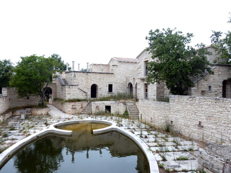
We were staying on the Istrian peninsula in what could best be described as an agricultural hamlet, mostly comprised of smallholdings and cottage style dwellings. These were all constructed in a similar style with what looked like local quarried stone. A network of paths and tracks connected up to other nearby hamlets which were also of a similar architectural style. When we stumbled across the half completed building above, it looked as alien to its surroundings as finding a mountain bothy in the middle of Las Vegas.
The scale of the building was completely out of proportion to anything else locally. The pick and mix collision of architectural styles created a bizarre postmodern mash-up with a tear shaped swimming pool or fish pond, bizarre minaret style columns half-built on the roof and Italian style interiors. What was clear, was that the building was the new that had never been. We wandered around the half completed rooms, bare wires hanging out of walls, yet opulent installed marble bathrooms. Work had clearly stopped some time ago with the extensive grounds already starting to be reclaimed by nature. It was as if we had walked into the film set of a Ballard adaptation, where the crew had disappeared.
Of course we had to construct some sort of narrative as to what had happened here. Ms A came up with the one that we settled on. The remote location, stilted opulence and rather garish tastes indicated that this could have been a low-key hideaway for some gangster or Mafiosi. Work on the property was well underway when they were either rubbed out, banged up, or cleaned out of money, leaving this rural fun palace to slowly begin to merge back into the Croatian countryside. The new that had never been.
.
X
Walking a line
an iridescent alchemist
pulls the sun
across the sky
.
XI
XII
That night, an absence of city light and gravity. We fell from earth, lost our breath, immersed in that plunge pool of dark sky. We learned to gather stars, eat planets for sustenance, grab comet tails to move. The dawn light made us heavy again. We fell back.
The commuters scurrying down the stairs at Rosyth Halt railway station, are unlikely to give much thought, if any, to the field on their left as they descend to the platform below. Some may notice subtle changes in colour throughout the year. The recent appearance of yellow broom blossom; the overhead sun creating a dappled patchwork of greens, sandy browns and heathery purple. In a few weeks, the hawthorn blossom will sit like scented snow on the ancient hedge.
Standing at a certain part of the station platform, it is possible to hear the gentle purr of the Whinny Burn tracing its route through the field on its way to the River Forth at Inverkeithing Bay. Magpies, rooks and collared doves appear to take a curious interest in the arrivals and departures of station commuters whilst overhead, the sun splinters around the extended wings of a buzzard soaring like Icarus ever higher into the blue.
The field is now bounded on all sides by motorway, dual carriageway and the railway line. A severed island of abandoned agricultural land cast adrift with no easy public access. At the top of the halt steps, there are no particularly distinguishing visual features as we look over the land which we are going to walk through. As a train arrives at the platform below, a late flurry of commuters hurl themselves past us and down the stairs to squeeze into the carriages before the doors close. Most are unlikely to be aware that there may be as many as 2,000 bodies buried somewhere in the vicinity.
The fields between the railway and the A823 (were) where the last and bloodiest part of the battle took place … it is likely to be where the majority of the killing took place. (Historic Scotland).
it is said that the burn ran red with blood for three days.
The casualties on the Scots side were certainly heavy. Most sources agree that about 2,000 were killed and around 1,500 taken prisoner, although various figures are reported for the casualties of the Highland regiments. Cromwell in his letter immediately after the battle reported at least two thousand dead.
July 1651
It was during the night or early morning of 16th /17th July 1651 that the troops of Oliver Cromwell’s New Model Army landed on the north shore of the Forth in the vicinity of Inverkeithing Bay. Whilst they had inflicted a heavy defeat on the Scottish army at Dunbar on 3rd September 1650, they had been thwarted by attempts to advance further into Scotland. Cromwell came to the conclusion that Fife was the key and by 20th July, 4,500 of Cromwell’s Parliamentarian force were dug in on Ferry Hills, whilst a Scottish force of a similar size had grouped at Castland Hill. The threat of Scottish reinforcements coming from Stirling provoked Cromwell’s Parliamentarians to attack and force the Scottish infantry to retreat north towards Pitreavie Castle. On land close to Pitreavie Castle, the Scottish infantry made a final stand but were soon overwhelmed by the more experienced Parliamentarians who had the additional advantage of cavalry. The Scots suffered heavy losses. This became known as The Battle of Inverkeithing (sometimes The Battle of Pitreavie) and was the last major battle of the Wars of the Three Kingdoms in Scotland. From 1652, Scotland was wholly under control of Cromwell’s Protectorate.
Entering the field is not too difficult. Not far from the station steps there is a locked gate but a little further along we find a gap in the hedgerow. If you are prepared to navigate or slide down a steep slope, this will deposit you amongst the discarded plastic bottles and assorted rubbish tossed from the stairs above. At ground level, the topography of the field is much more apparent. Pronounced undulations ahead of us, sloping off to the right towards marshy ground around the Whinny Burn. Ground cover is a mix of meadow type grasses, whin bushes, dandelions and what look like dock leaf plants gone to seed.
You only have to look towards the perimeter of the field to be aware that you are surrounded by human presence. The rooftops of Rosyth to the right and the hum of motorway traffic a constant low-level signal. Yet on the actual land we are walking, it is rare to find an almost complete lack of evidence that humans have recently passed. No litter, no discarded cans or bottles or burnt out barbecues. There are hints of desire lines traversing the space, perhaps made by committed dog walkers or something else. It is only as we move further into the field, that there is a clear sense that we are being watched.
At first, we wonder if it is a dog but it soon becomes apparent that it is the eyes of a tiny roe deer that are fixed on our movements. We are both probably equally surprised to encounter each other. This is not an area where you would typically expect to see deer. Where on earth has it come from? We lock into that non-time state of reciprocal, motionless, staring. Eventually the deer decides to break for it. Great elongated leaps for something so small; as if bouncing off the air itself, not really touching the ground. I manage to retrieve the camera and fire off some random shots in the hope that we obtain some record of this actually having happened.
as if bouncing off the air itself
We notice our presence is also alarming a number of skylarks which appear to have made the field their own. Their nervous, vertical flight and fluted song a mix of terror and beauty as we try to avoid what must be their nesting areas.
The field separates in two at a ridge of hawthorn bushes. On the other side:
From a distance
criss-cross
to new horizons
A field of time
history layered
on geography.
Transparent globes
of wind held tension
time scattered
yellow flowerings
of the eternal return
The field eventually tapers to a point where we can go no further, blocked off by the railway and the smooth, solid concrete structure carrying the A823 motorway spur.
We know that beyond the A823 another field will take us to a concrete flyover of the M90 motorway. We work out a way to access the field and head off on a detour. Our serendipitous findings are recorded in a separate blog: Cartographies of Chance – Underneath the M90 (II).
Returning to the field, we walk close to the northern perimeter with only a thin hedgerow between us and the A823. Such a slight threshold separating us from our field of time, skylarks and deer. On the other side, the surveillance cameras, crash barriers, lay-bys and signs – all the material apparatus of the modern motorway.
We are quite surprised to come across a footbridge over the motorway that enters the field only to stop at a complete dead-end. The proximity of this easier access results in the usual heaps of fly tipping, something that is hard to understand. It must be much more difficult to dump this stuff here than take it to the municipal waste recycling.
Place and non-place are rather like opposed polarities: the first is never completely erased, the second never totally completed . . . But non-places are the real measure of our time.
Marc Augé
The footbridge takes us over the A823, (Why does an empty motorway always evoke a Ballardian descriptor?) and into the relatively new ‘non-place’ of Carnegie Campus. We know from the old maps and records that this land was also once part of ‘the field’. Being a Sunday, the ‘campus’ is completely deserted as we wander amongst the new build office blocks, many of which still look unoccupied. Roundabouts appear to have been built in hope of a time still to come as roads come to an abrupt end. Rab’s Little Kitchen snack van is closed.
Where the manicured non-space runs out, an explosive wild bouquet of whin sits amongst a covering of red campion:
And yet amongst all the shiny new sheen of this place, older voices intrude. A hexagonal brick structure whose original purpose is unclear:
time stacked textures
brick and concrete
.
Nestled in at the side of the main road into the campus we come across the cairn. As far as we are aware it is the only explicit acknowledgement of what happened on this land.
the Scots were driven back to the level ground between Hillfield and Pitreavie. Here, in one of the most famous episodes of the Battle of Inverkeithing, the Clan Maclean of Mull regiment, commanded by their chief, Sir Hector, found themselves surrounded by superior enemy forces. The clansmen fought fiercely in defence of their chief, calling out, “Fear eile airson Eachainn!” (Another for Hector!), as they sacrificed themselves.
The battle involved musketry, cavalry, pikes, swords and even archery on the Scottish side, with considerable hand to hand fighting
Near here, Sir Hector MacLean of Duart was killed
at the Battle of Inverkeithing
along with some 760 of his men
20th July 1651
“Another for Hector”
Nearby to the cairn, stands another material presence in the layered history of the field. Peering over a substantial stone wall allows us a view of the Dovecot in the grounds of Pitreavie Castle.
Pitreavie Castle was originally built in the early 17th century by Henry Wardlaw of Balmule, later Sir Henry Wardlaw, 1st Baronet of Pitreavie. Wardlaw was Chamberlain to Queen Anne, wife of James VI of Scotland.
The Battle of Inverkeithing/Pitreavie was fought nearby on 20 July 1651, between an English force commanded by Colonel Robert Overton and a Scottish force, including some 800 Highlanders from the Clan Maclean. After the battle, which was a decisive victory for the Cromwellian forces (contemporary reports speak of 2,000 Scots killed and 1,600 captured, all for the loss of 8 of Overton’s troops), a group of Macleans sought refuge in Pitreavie Castle. The Wardlaw family refused them sanctuary and the Macleans were likely to have been captured or killed.
The Maclean dead … are more likely to have been buried in a mass grave.
We pass the old dovecot of the castle, turn left and past the front door where the initials of Henry Beveridge are recorded. Beveridge purchased the Castle in 1883 and extensively remodelled it in 1885.
Henry Beveridge was a wealthy mill-owner, philanthropist and educator from Dunfermline. He was an associate of Patrick Geddes having attended Geddes’s summer meetings in Edinburgh. He subsequently became one of the Directors of Geddes’s Edinburgh Town and Gown Association in 1896. As a member of the Carnegie Dunfermline Trust, Beveridge was also partly responsible for arguably Geddes’s greatest work – City Development: a study of parks, gardens and culture institutes. A report to the Carnegie Dunfermline Trust. Geddes also introduced Beveridge to the artists John Duncan and Charles Mackie who painted murals in the castle illustrating the legend of Orpheus and Sir Patrick Spens.
International Studio, 1897
It is believed that these murals may now be at best over-painted and at worst destroyed. A good example of John Duncan’s Symbolist style can be seen in his famous work, The Riders of the Sidhe:
As noted above, Henry Wardlaw’s granddaughter-in-law, Elizabeth Wardlaw, is claimed to be the author of Sir Patrick Spens. (Although the evidence appears somewhat tenuous).
“The king sits in Dunfermline toune drinking the blude reid wine, “O whar will I get a guid sailor, To sail this schip of mine?”
…
Walking past Pitreavie Castle today, it has now been converted into flats and apartments and offers no clue as to another more recent past life. It was bought by the Ministry of Defence in 1938 and after the second world war, deep in a basement bunker became the headquarters of NATO’s Northern Maritime Region. During the Cold War, all Soviet ships and submarines on exercise in the North Sea were monitored from here. The base closed in 1996 and operations moved to RAF Kinloss. There is little or no outward trace of this today, although some photographs of its past life exist:
Access to the underground bunker
(c) Subterranea Britannica
The teleprinter room 1944
(c) Subterranea Britannica
As we head along Castle Drive, we notice that a small housing estate has a story hidden in the street names:
Covenanters Rise: The Scottish army was a Covenanter army, acting under allegiance to Charles II.
MacLean Walk: the aforementioned Sir Hector Maclean of Duart, commander of the Scottish Highland infantry.
Sir John Brown Place: Sir John Brown, commander of the Scottish lowland infantry.
Overton Crescent: – Colonel Robert Overton led the assault party of New Model Army troops that landed in Fife on the night of 16th/17th July.
Our final part of the walk will take us along Castle Drive where we will loop around to bring us back to where we entered the field. Despite the changes over the centuries, we have walked the area of the field as it was in 1657. We continue to ponder our mysterious encounter with the roe deer. Perhaps a manifestation of “only shadows here”?
Four days after the Battle, Cromwell crossed to Fife in person. For him the victory was “an unspeakable mercy”.
As we walk down Castle Drive we pass another new addition to the landscape on the left. A customer contact centre for Rupert Murdoch’s Sky empire.
On the other side of the road, a magpie picks at the carcass of a dead squirrel.
≈≈≈
Appendix
Present day map showing the boundary lines and key sites of the Battle of Inverkeithing. (Historic Scotland/Ordnance Survey).
Now playing: June Tabor – ‘Sir Patrick Spens’ from An Echo of Hooves.
or a more jaunty version: Fairport Convention – ‘Sir Patrick Spens’ from Full House.
References:
Marc Augé, Non-places: Introduction to an Anthropology of Supermodernity (London and New York: Verso, 1995).
Charles Holme (ed), The International Style, Vol. 1 No. 1 (New York: The Bodley Head, March 1897).
Helen Meller, Patrick Geddes: Social Evolutionist and City Planner (London and New York: Routledge, 1993).
Wisława Szymborska, Map: Collected Poems and Last Poems (Boston and New York: Mariner Books, Houghton Mifflin Harcourt, 2016).
Ben Wheatley Dir. A Field in England (Film4, 2013). Film.
Area Combined HQ Rosyth – Pitreavie Castle (Flag Officer, Rosyth, RN & AOC No 18 Group, RAF Coastal Command) on Subterranea Britannica
The Inventory of Historic Battlefields – Battle of Inverkeithing, Historic Scotland, 14th December, 2012.